
How Wind Farm Locations Are Chosen: Key Factors Explained
The best locations for wind turbines are not simply the windiest. A viable site combines a productive and predictable wind resource with grid capacity, buildable ground or seabed, acceptable environmental effects, permits, community considerations and practical construction and maintenance access.
Developers screen broad areas, measure promising sites and then refine turbine positions through energy-yield, wake, ground or seabed, environmental, logistics and financial studies. Onshore and offshore projects use the same decision logic but face different constraints.
Where are wind farms located?
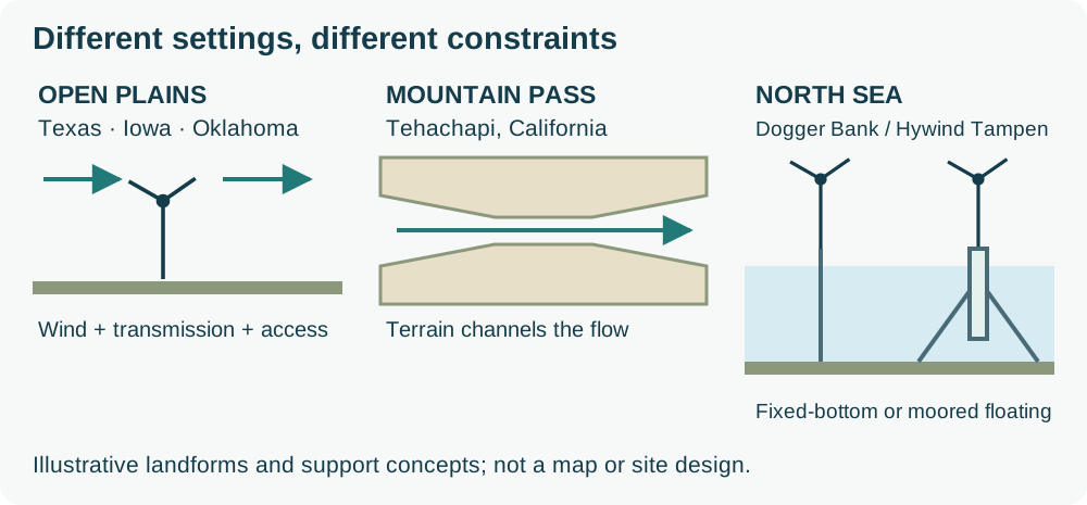
Wind farms occur on open plains, smooth ridges, mountain passes and offshore waters where a workable resource coincides with grid access, suitable foundations and acceptable effects on other users. These examples show different settings, not a ranking of the world’s best sites.
| Region / example | Verified location fact | Selection factor illustrated | Source / date |
|---|---|---|---|
| Central United States | Texas, Iowa and Oklahoma were among the five leading states for wind generation in 2025. | Open inland resources still need viable transmission and access. | EIA, 2025 generation data |
| California, United States / Tehachapi | Wind is channelled through a mountain pass; the EIA describes seasonal and afternoon patterns. | Terrain acceleration and the timing of production matter. | EIA geography explainer, checked 4 November 2026 |
| UK North Sea / Dogger Bank A | About 131 km from shore at its nearest point. | Export cables, installation and maintenance distance accompany the wind resource. | Project owner, checked 4 November 2026 |
| Norwegian North Sea / Hywind Tampen | About 140 km offshore in 260–300 m water, using floating concrete spars and moorings. | Deep water changes support and access concepts; depth alone does not decide viability. | Equinor, checked 4 November 2026 |
Can wind turbines be placed anywhere?
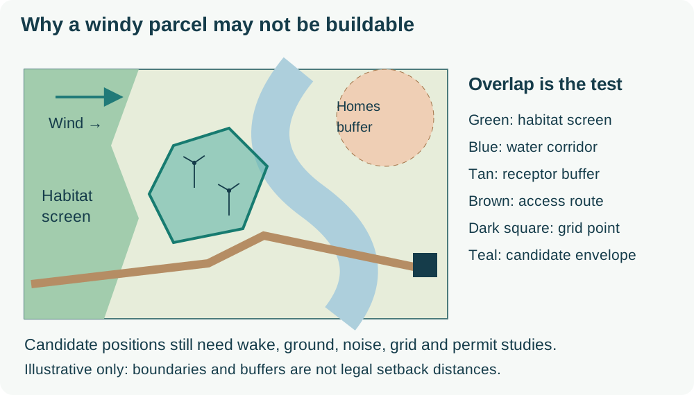
No. A windy parcel may be excluded by incompatible land or seabed use, environmental effects, aviation or radar conflicts, unsuitable ground, access limits or an unworkable grid connection. Which constraint is decisive depends on the jurisdiction and project. For example, the UK’s 2025 renewable-energy planning statement addresses offshore site choice, navigation and environmental effects; its rules are not global setback standards.
1. Regional Screening and Wind Resource Assessment
During early screening, developers compare wind speed and direction by height and season, turbulence, extreme winds, shear, and effects from terrain or neighbouring turbines. There is no universal viability threshold: turbine model, energy price, losses, grid cost, and financing all affect the minimum acceptable resource.
Meteorological masts and LiDAR provide site measurements, while long-term reference data helps correct shorter campaigns for interannual variation. Developers combine the measured wind climate with terrain and turbine models to estimate gross production, wake and availability losses, uncertainty, and expected net energy yield.
For initial context, EIA’s siting explainer cites annual-average speeds of at least 9 mph (4.0 m/s) for small turbines and 13 mph (5.8 m/s) for utility-scale turbines. These are screening guides, not guaranteed economic thresholds, design limits or permission to build. Measurement height, turbine curve, turbulence, losses and costs still matter.
A stronger resource can improve energy yield, but only after wake, availability, electrical and curtailment losses are considered alongside project cost and risk.
2. Micrositing, Layout and Wake Effects
After an area passes the first screen, micrositing tests candidate turbine positions and layouts. The design weighs prevailing wind direction, turbine model and hub height, setbacks, environmental buffers, land parcels or seabed leases, road and foundation constraints, and electrical collection routes.
Wake losses are part of that layout decision. An upstream turbine can leave slower, more turbulent air for a downstream turbine, reducing energy yield and affecting loads. Developers model wakes and compare spacing, orientation, turbine count, access, and cable cost instead of choosing positions on wind speed alone.
3. Grid Connection and Export
A strong wind resource is not enough if the project cannot connect. Developers examine available network capacity, substation location, voltage and connection requirements, the route for new lines or cables, and the risk of curtailment or export limits. Distance matters, but capacity and interconnection feasibility can be just as decisive.
Onshore projects may connect through existing substations or new overhead or underground infrastructure. Offshore projects add array cables, an export route, a landfall and an onshore substation, so the grid study must consider both the marine and land-based parts of the connection.
4. Land use, terrain and water depth
Open terrain often simplifies wind modelling and construction, but viable onshore projects can also be built in forested or complex terrain when resource, access, foundations and environmental constraints are manageable. Long-term access should be considered alongside onshore wind farm maintenance needs.
Offshore screening adds water depth, seabed and metocean conditions, foundation concept, export-cable route, shipping, defence and aviation constraints. Distance from port and shore affects installation and offshore wind maintenance, but deeper or more distant sites may still be viable with suitable technology and economics.
Land ownership also plays a role—negotiating with multiple landowners can delay projects and complicate planning.
5. Environmental & Wildlife Impact
Projects are assessed under the applicable environmental and planning rules. Surveys may examine protected habitats, birds, bats, peat, water, landscape, noise and cumulative effects. Findings can change the boundary, layout, construction timing, monitoring and mitigation plan.
Marine wind farms go through similar scrutiny—examining sea life, fish migration, and coastal ecosystem sensitivity. A poorly placed turbine could disrupt local biodiversity or lead to public opposition.
Operational and maintenance plans should incorporate the project’s approved environmental controls, seasonal restrictions, monitoring commitments and site-access rules.
6. Access and Logistics
Construction equipment, turbine components, and maintenance teams must reach the site easily. Remote areas with no road access can lead to major delays and increased costs.
For offshore projects, developers evaluate port infrastructure, vessel and helicopter strategies, transfer limits and weather downtime. Access planning continues into operations: specialist rope access services may support suitable inspection and maintenance scopes where the task-specific risk assessment permits.
7. Regulatory and Permitting Requirements
The approval route is jurisdiction-specific. Developers identify the applicable planning and environmental process, noise and aviation constraints, land or seabed rights, grid requirements and stakeholder consultations before detailed design.
The permitting process can take years, and understanding legal frameworks early on is crucial. Developers must also engage with local communities, address concerns, and secure land-use agreements.
8. Economic Viability
A viable site must produce an acceptable risk-adjusted return. The model combines net energy yield and price assumptions with development, grid, construction, financing, lease, operations, maintenance and decommissioning costs. Site selection is the first stage of the wind turbine life cycle, and those later costs depend on decisions made here.
Sensitivity tests show whether changes in wind yield, downtime, construction cost or power price undermine the business case. For offshore projects, Gridinta’s guide to offshore wind-resource science explains why roughness, stability, shear, wakes and the full rotor layer belong in that evidence rather than one average wind speed.
Wind farm site-selection matrix
| Factor | Evidence used | Potential exclusion or redesign trigger | Onshore / offshore difference |
|---|---|---|---|
| Wind and wakes | Height-resolved measurements, long-term reference and layout models. | Unacceptable net yield or loading. | Terrain and obstacles / marine stability and neighbouring arrays. |
| Grid | Connection study, capacity, export route and costs. | No workable connection or export envelope. | Road/land corridors / subsea route, landfall and onshore export. |
| Ground or seabed | Geotechnical and topographic or bathymetric surveys. | Unsupported foundation concept or uneconomic civil works. | Soil and access slopes / depth, seabed and moorings. |
| Environment and other users | Site-specific surveys and consultation. | Effects that cannot be acceptably avoided or mitigated. | Habitats and homes / navigation, fisheries and marine ecology. |
| Access and economics | Delivery routes, port capacity, weather and cost sensitivity. | No practical installation or maintenance strategy. | Roads and crane pads / ports, vessels and marine windows. |
From a candidate site to an operating asset
Siting belongs to the development team. Once an asset is operating, access and layout affect inspection and corrective work throughout service; Gridinta’s onshore wind turbine maintenance services describe that operating scope.